
 Ziya
Ziya Share
Share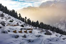
The Meteorological Centre has issued a fresh weekly forecast for Uttarakhand, signaling a "dual weather" pattern. While the higher reaches of the Himalayas are expecting fresh snowfall and thunderstorms, the plains, including Dehradun and Pantnagar, are moving rapidly toward early summer heat.
High-Altitude Rain & Snow Alert
A feeble Western Disturbance is currently active over the region, with another expected to strike around March 26-27, 2026.
Districts on Alert: Uttarkashi, Rudraprayag, Chamoli, Bageshwar, and Pithoragarh.
Snowfall Zones: Areas situated at an altitude of 3,300 meters and above are likely to witness light to moderate snowfall.
Thunderstorm Warning: Isolated places may experience lightning and gusty winds reaching speeds of 30-40 kmph, especially on March 23rd and 27th.
Heatwave Incoming for the Plains?
While the mountains stay cool, the rest of the state is seeing a sharp climb in mercury.
Temperature Surge: Maximum temperatures across the plains are expected to rise by 4°C to 7°C over the next few days.
Dehradun & Haridwar: Expect clear skies and dry weather, with temperatures potentially crossing the 33°C–35°C mark by the weekend.
Dry Spell: For the remaining eight districts, the IMD predicts primarily dry and sunny weather, making it feel like peak summer sooner than expected.
Travel Advisory for Tourists
If you are planning a trip to Char Dham routes or high-altitude trekking:
Check Road Status: Fresh snow in the upper reaches can lead to temporary road blockages or slippery conditions.
Safety First: During thunderstorms, avoid taking shelter under trees or parking vehicles near steep slopes.
Hydration: For those in the plains or low-lying valleys (like Rishikesh), keep hydrated as the afternoon sun intensifies.