

 Ziya
Ziya Share
Share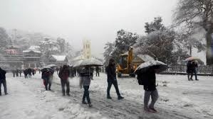
If you live in Uttarakhand or are planning a cozy winter getaway to the hills soon, you might want to keep an extra jacket handy. The weather is about to take a sharp turn. While we have been dealing with the usual winter chill, the Meteorological Department has signaled that the next few days specifically up until January 23rd are going to see a significant shift.
The Mountains Are Calling (For Snow)
The biggest update is for the higher altitudes. If you love the sight of snow-covered peaks, this is good news for you. The forecast suggests that areas sitting at a height of 2,500 meters or more are likely to receive a fresh coat of snowfall.
Districts like Chamoli, Pithoragarh, and Uttarkashi are on the radar. So, if you are a tourist chasing snowflakes in places like Auli or near the shrines, you might just get lucky. However, for the locals, this means the biting cold is going to get a little more intense.
Rain for the Plains
It’s not just about snow. The lower hills and plains aren't escaping the change either. The weather department predicts light to moderate rain in various parts of the state. It looks like the Western Disturbance is active again, bringing moisture and clouds with it.
This combination of rain in the lower areas and snow on the peaks usually creates a "deep freeze" effect. The day temperatures might drop, and the nights are going to feel significantly colder.
What Should You Do?
If you have travel plans, especially driving up the mountains, be a little cautious. Roads can get slippery with rain and sleet, and visibility often drops when the weather packs up like this. It is always smart to check the specific route status before you start your engine.
For those staying home, it’s the perfect excuse to keep the heaters on and enjoy some hot tea. The forecast till January 23rd indicates that winter isn't ready to leave just yet. Stay warm and keep an eye on the sky!


_132300150_100x75.jpg)
_430488585_100x75.jpg)
_1333714631_100x75.jpg)
_58079313_100x75.jpg)